


Introduction to Surveying

Definition of Surveying– Surveying is defined as the science of making measurements of the earth specifically the surface of the earth. This is being carried out by finding the spatial location (relative / absolute) of points on or near the surface of the earth.
Aims of field surveying –
- To measure the Horizontal Distance between points.
- To measure the Vertical elevation between points.
- To find out the Relative direction of lines by measuring horizontal angles with reference to any arbitrary direction and
- To find out Absolute direction by measuring horizontal angles with reference to a fixed direction
Objectives of Surveying-
- To collect field data;
- To prepare plan or map of the area surveyed;
- To analyze and to calculate the field parameters for setting out operation of actual engineering works.
- To set out field parameters at the site for further engineering works.
Divisions of Surveying-
Based upon the consideration of the shape of the earth, surveying is broadly divided into two types.
- Plane Surveying
- Geodetic Surveying
| Classifications of Surveying |
| Ø Based on the purpose (for which surveying is being conducted), Surveying has been classified into:
Ø Control surveying: To establish horizontal and vertical positions of control points. Ø Land surveying: To determine the boundaries and areas of parcels of land, also known as property survey, boundary survey or cadastral survey. Ø Topographic survey: To prepare a plan/ map of a region which includes natural as well as and manmade features including elevation? Ø Engineering survey: To collect requisite data for planning, design and execution of engineering projects. Three broad steps are Ø Reconnaissance survey: To explore site conditions and availability of infrastructures. Ø Preliminary survey: To collect adequate data to prepare plan / map of area to be used for planning and design. Ø Location survey: To set out work on the ground for actual construction / execution of the project. Ø Route survey: To plan, design, and laying out of route such as highways, railways, canals, pipelines, and other linear projects. Ø Construction surveys: Surveys which are required for establishment of points, lines, grades, and for staking out engineering works (after the plans have been prepared and the structural design has been done). Ø Astronomic surveys: To determine the latitude, longitude (of the observation station) and azimuth (of a line through observation station) from astronomical observation. Ø Mine surveys: To carry out surveying specific for opencast and underground mining purposes. Latitude: the angular distance measured along a meridian above or below the plane of the equator. |
Longitude: The angular distance measured in the plane of the equator east or west of the Greenwich Meridian.
| Principles of Surveying |
| The fundamental principles upon which the surveying is being carried out are
Ø Working from whole to part. Ø After deciding the position of any point, its reference must be kept from at least two permanent objects or stations whose positions have already been well defined. .
|
- Fundamentals of Mapping
The data collected through field surveying are presented in the form of a plan or a map
Plan: Orthographic representation of features on or near the surface of the earth in Large Scale on a horizontal plane
Map: Graphical representation of features on or near the surface of the earth in small scale on a horizontal plane and is constructed using a projection system other than orthographic.
Scale: A specified distance on a map representing corresponding distance on the ground.
The selection of scale is one of the most important considerations during mapping. It is decided on the basis of:
- Purpose of the map;
- Nature of terrain to be mapped;
- The size of the final sheet;
- Availability of resources to get it prepared and printed.
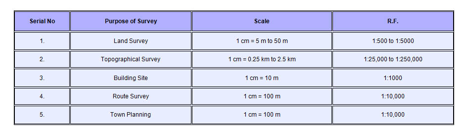
Suggested scales for different types of survey
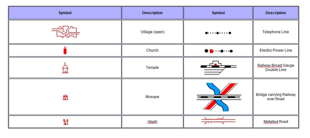
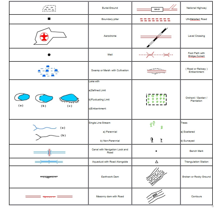
Standard (Survey of India) Conventional Signs of Salient objects for Topographic Map
Map Generalization
The process involved in selecting the essential details from the multitude of topographical objects and representing them in a specified manner is called ‘generalization’. It serves the purpose of facilitating the production of a legible homogenous map.

Comments